-
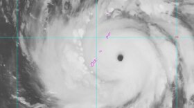 At 1 a.m. Monday, the system was located at 13.7 north latitude and 146.9 east longitude, about 134 miles east of Andersen Air Force Base. It was packing winds of 180 mph and gusts of 215 mph as it approached the island chain.
 -
 The National Weather Service will issue a typhoon watch for Rota, Tinian and Saipan at 2 p.m. Friday, according to CNMI officials. Guam will be in COR 3 at 3 p.m.
 -
 There is uncertainty about the system's forecast track, but Guam and the CNMI are within the area of concern.
 -
 Residents are being advised to stay out of the water and prepare for a strong typhoon, which will likely hit overnight Monday
 -
 As of 5 p.m. Friday, the storm was forecast to pass over Guam, possibly as a Category 3 or 4 storm, sometime Monday night and early Tuesday.
 -
 Forecasters warned of rough seas, high winds and rain as an intensifying tropical storm was expected to pass between Yap and Guam Monday and Tuesday.

© 2026
Isla Public Media KPRG
Play Live Radio
Next Up:
0:00
0:00
Available On Air Stations


